The region we had chosen for this leg of the journey was the coast of the state of Michoacán, the same state in which we’d already spent several days inland. This particular stretch of coastline was the last in Mexico to become accessible by a highway. Only 10 years ago, it was a complete backwater, and it is still mostly undeveloped compared to other parts of the Pacific coast. Here we hoped to find some pristine beaches with cheap camping, minus the hordes of tourists that flock to other coastal areas.
Our guidebook had recommended El Faro de Bucerías as a lovely beach with yellow sand, plenty of camping, and good surf for swimming. The book was right on all of the above; however, due to its proximity to the highway heading back inland to the larger cities, it apparently has become very popular with Mexican tourists. Hundreds of Mexican families had already set up their tents in the sand under the many thatched-roof enramadas, and little kids, rowdy teen-agers and crappy music were everywhere. Nevertheless we decided to stick it out for a night here, as the price was nice compared to what we’d been paying – about $3US to pitch our tent in the shade, with free access to bathrooms and a shower. Staying here at El Faro was not such a good choice, though, as it turns out, since a group of boisterous drunks partied less than 5 feet from our tent until what seemed like 2 in the morning. The next morning, Friday, the neighboring children made sure we couldn’t sleep until past 8am, so we packed up and headed out.

The beach at El Faro
On Friday we back tracked a bit in search of a public telephone which was surprisingly hard to find in the beachside villages. We finally found a larger town, where Carley was able to call and sing “Happy Birthday” to her mom. We stocked up on provisions there, and after a 20 minute drive, we rolled into a very promising-looking beach called La Ticla. The beach was much less crowded, and there was plenty of wide open space under the enramadas for setting up a peaceful camp. We quickly gathered that this was a surfing beach, judging from the huge waves and high percentage of California license plates. The camping price was even cheaper here, about $2.50US. The owner of the enramada was a lovely local Nahua (indigenous) woman named Amalia who made us feel right at home. We enjoyed our one-night stay here, though we didn’t end up socializing with the gringos – there seems to be a tendency with surfers to be a bit snobbish toward non-surfing tourists here. Since our primary water activity was to be swimming, this beach was not really our style, since the enormous pounding waves made it rather dangerous to be out there without a board. Also the black sand here (evidence of nearby volcanic activity) was much more persistent in getting into and all over everything.

Carley and the surfers (La Ticla)

Rob and Kina at La Ticla

Amalia, our gracious hostess at La Ticla
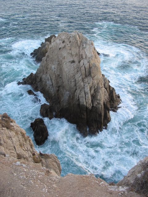
On Saturday we rolled about 50 miles down the coast to what our guidebook describes as probably the most beautiful beach in Mexico – Maruata. Now we were really out in the middle of nowhere, in a small village with no other villages anywhere nearby. And as promised, this beach is extremely picturesque. Several very large rock formations here divide the coast up into several smaller beaches, some with large pounding surf, others with nice swimming areas. In a few places, the ocean had carved tunnels through the rock formations, and sight of huge waves exploding out of these caves on to the beach was a sight to behold. These turbulent areas were definitely not safe for swimming!
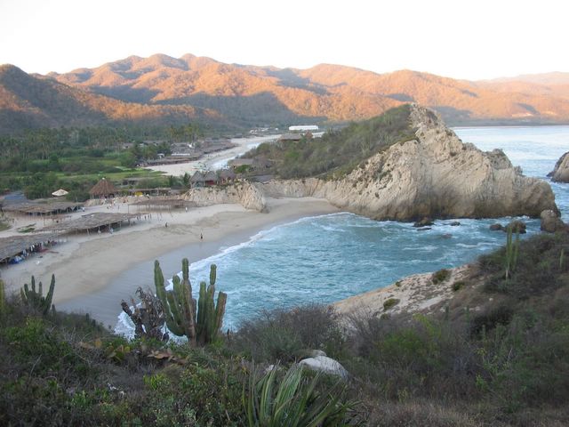
Beautiful Maruata

Our camp at Maruata

Kina's not afraid of the approaching cave wave (Maruata)
Schwirl at Maruata!!
There was one area which Rob dubbed “the kiddie beach” that was great for floating around in the ocean without fear of being dragged 20 feet by a ridiculous current. All of us swam at this beach – Kina included. As Carley was swimming back to shore during a brief swim, she noticed that all of the people standing in shallow water were staring wide-eyed at something passing them in the water. Upon closer observation, that something proved to be Kina. We think that she either a) likes to swim; or b) has such severe separation anxiety that she would prefer risking a watery death to being without her parents. She also has a tendency to bark at us every time we exit the ocean, as if she’s not sure whether or not we’re the same people who went in.
Maruata seems to be a party spot for Mexican teenagers and 20-somethings (not many families here, and almost no gringos), and the campsite next to ours smelled like a Grateful Dead concert all day long. However things never got too rowdy or boisterous. This turned out to be the perfect spot for us to celebrate Fest-Fest, in solidarity with some of our friends in northern California. Fest-Fest is a mostly obscure holiday celebrated in early spring, originating in northern California – though it has reportedly spread to Thailand due to migration – and always involving tequila!

Rob celebrates FestFest at Maruata
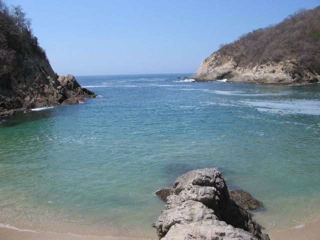
Thanks to the tequila, we were a bit hung over on Sunday morning. Nevertheless, we decided to push on down the coast, in search of complete solitude. While generally we like party spots, especially if our friends are around, the feeling is different when it’s just the 2 of us. About 30 miles south, we found a real jewel, a tiny peaceful village called Pichilinguillo. (We decided to shorten the name and call it Peachy, in honor of our friend by the same name who is also a gem.) Pichilinguillo is still in the middle of nowhere, on a small beach situated on a tiny bay surrounded by cliffs on 3 sides. The beach had just one enramada, and it was empty – we would be the only campers here! Here we felt we were in heaven! We swam to our heart’s content, and enjoyed almost complete privacy on the secluded beach (with the exception of a few occasional children and dogs from the village).
Our own Blue Lagoon, Pichilinguillo
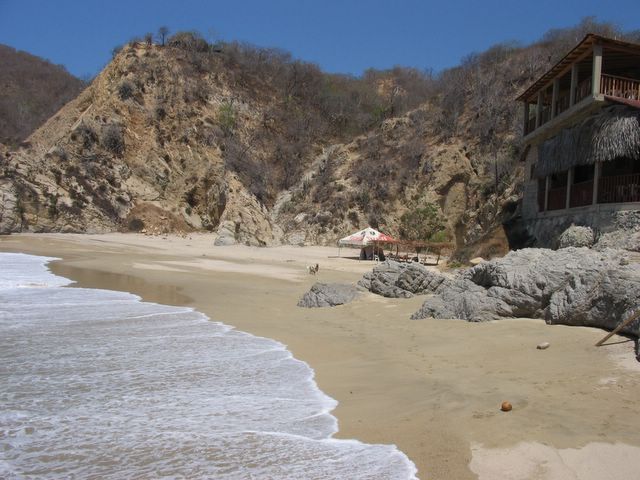
All alone at Pichilinguillo
The proprietors of this enramada are a very nice family, headed by the beautiful Flora and her talkative husband Ignacio, that live in a house on the cliff off to one side of the beach, and they operate a modest restaurant with a lovely patio over-looking the crashing waves – a very convenient luxury. After getting to know the family, we discovered that they had lived in the Bay Area for a number of years. “íEl mundo es chiquito!” laughed Ignacio when we told him we just left Oakland. The world is small indeed.
We definitely felt tempted to stay here in Peachy a few days; however, with so much more ground to cover in the next 2 weeks, plus the rather immediate need for Internet access, we decided to hit the road again on Monday morning. However, this is a place we would definitely like to visit again sometime. In fact, the whole area around Pichilinguillo is extremely enticing, as we passed by quite a number of absolutely deserted beaches that were just beckoning us to come on out and stay awhile. With the rural ambience of this region due to the lack of over-development, this area is one of Mexico’s last hidden treasures – though we doubt it will stay this way for too much longer.
A few hours south of Pichilinguillo, we came upon the next major inland-bound highway, and suddenly our surroundings were much more urban again, with a huge increase in traffic, speed bumps and roadside vendors. Around this time we crossed the state line from Michoacán into the much more developed coastline of the state of Guerrero, which is home to two of Mexico’s mega-resort cities, Ixtapa and Acapulco. Shortly we drove past Ixtapa, catching a glimpse of its resort hotel towers in the distance, but opting not to pay for a $150 hotel room here amidst the golf courses, water slide parks, dolphin shows, and booming discos – this was not the Mexico we were looking for.
Just 10 minutes past Ixtapa (still a couple hundred miles northwest of Acapulco) we arrived in the laid-back seaside tourist town of Zihuatanejo (locally known as Zihua – pronounced see-wah). Decidely more seedy and low-key, but packed with bars, restaurants and Internet cafes, this seemed like a decent place to re-charge and get the sand out of our ears.
On to DAYS 15-17: La Costa Grande - Zihuatanejo and Acapulco