Wednesday, January 11, 2006

SAN MARCOS - New Year's Eve with Kan'Nal at Lake Atitlán


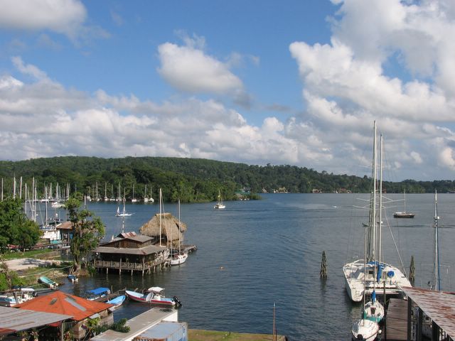
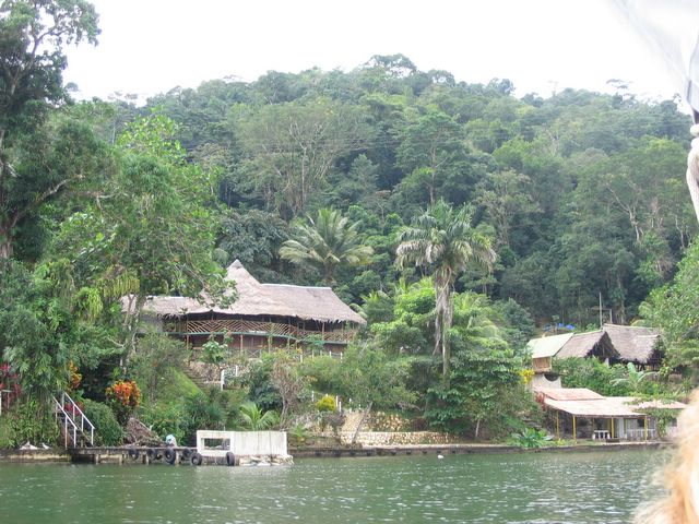
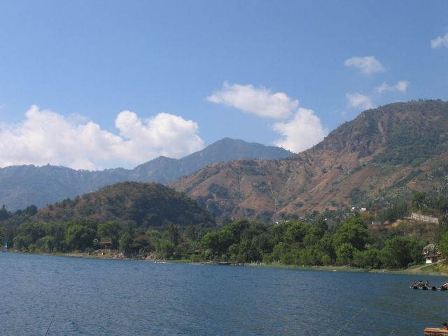
The lakefront at San Marcos, Lake Atitlán

After bouncing around the country for the past 2 weeks, it was so nice to return to one of our favorite spots anywhere, the stunningly beautiful Lake Atitlán. The lake has become our favorite weekend getaway (about once a month these days), but usually we stay in San Pedro. This was our first time in San Marcos.

Like San Pedro, San Marcos has its touristy area down near the lake shore, while the traditional indigenous village is located a little way up the hill from the lake. And also like San Pedro, the touristy area of the village has dirt trails instead of roads, leading through a lush, verdant forest setting with hotels, restaurants and meditation centers set amongst all kinds of flowers, fruit and coffee trees.


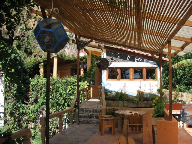
The place we particularly liked was Moonfish Café & Restaurant. Owned by an expat gringo named Shep, the place specializes in fantastic vegetarian food, much of it organic and grown on the property. In the photo, the open-air dining area is on the left, while the kitchen is the building on the right. Part of the organic vegetable garden is shown in front of the kitchen.


Shep also has a couple of large teepees in the back of the Moonfish restaurant which you can sleep in for the night instead of staying in a hotel. He also provides a small kitchen like you would find at a hostel. We set up our tent next to this teepee. (to the left and a little behind it)


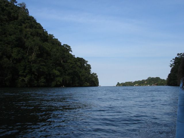
To reach Moonfish, we had to walk 5 minutes from the main road on a series of paths and dirt trails. You could also reach it by boat, since it’s right on the lake.


This beautiful hotel, Aaculaax, was just next door to Moonfish. This is where our friend Jessica stayed.


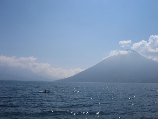
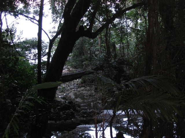
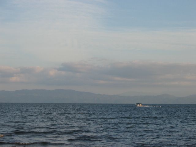
The view of Lake Atitlán from the little beach in front of Moonfish.


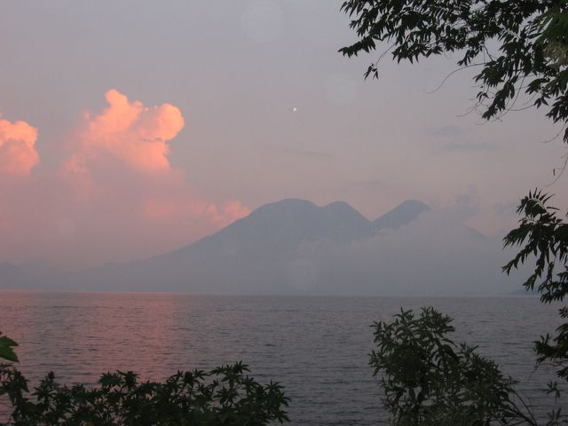
Sunset from San Marcos, looking toward the volcanoes Atitlán (left) and Tolimán.


The main event in town on New Years Eve was a concert by the primal psychedelic Latin rock band, Kan’nal.


Formed here in San Marcos several years ago by a variety of young travelers from the US and Canada, Kan'Nal has recently broken into the US touring and summer festival circuit. They drew some rave reviews at the famous High Sierra Music Festival in northern California.


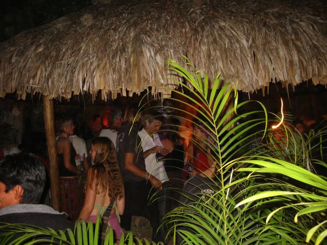
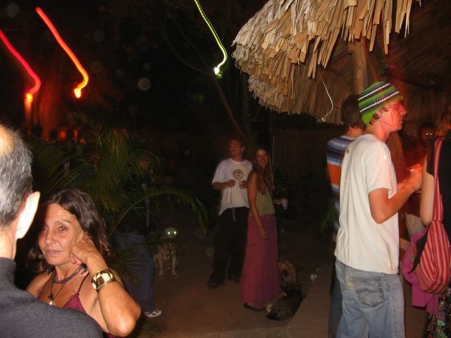
The show took place under a large thatched-roof-covered veranda at a beautiful hotel/restaurant called La Paz (Spanish for Peace).
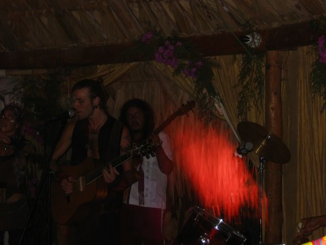

Kan'Nal in action.


Carley and Kina chilling in the back of the audience. Many in the audience had painted faces.


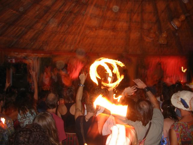
Fire dancers at times accompanied the band, despite the thatched roof overhead. Fire marshalls don't seem to have the same command here in Guatemala that they do in the US.


Bonfire schwirl

HAPPY 2006!!

Back to the main page

Tuesday, January 10, 2006

LIVINGSTON - Guatemala's Caribbean culture


The port in Livingston where our lancha arrived from Río Dulce.

Livingston is one of the few towns along Guatemala's tiny slice of Caribbean coastline. (Belize and Honduras take up most of the coast in this area) At the mouth of the Río Dulce, Livingston is only reachable by boat, since there are no roads to connect it to the rest of the country. There are some cars on the streets in the town, but most are taxis that arrived here on boats. This make Livingston a much nicer town to walk around than many other towns in Guatemala, which are often grating with the blare of car horns and the choking clouds of black exhaust.


Street performance in Livingston

Livingston is most famous as the home of Guatemala’s Garífuna culture. The Garífuna are "Black Caribs" who are descended from 2 boats of African slaves from Nigeria that were shipwrecked in 1635 on the Caribbean island of Saint Vincent. There the Africans intermarried with the native Carib culture for over 150 years. After a British invasion of the island in 1796, around 4000 of the darkest-skinned Garífuna were deported by the British to Roatán, just off the coast of Honduras. Since then the Garífuna have spread all along the Caribbean coast of Central America, from the south of Belize all the way down to Nicaragua. The distinct Garífuna language is derived from the Carib culture. However the majority of Garífuna people in Guatemala also speak Spanish, so we were able to communicate just fine with them.

We weren’t really expecting much from Livingston, since its beaches are mostly tiny and lackluster. In fact the "beaches" within the town limit are downright polluted and definitely not recommended for swimming.


However we did find this pretty little beach a few miles north of Livingston. (The islands in the distant background are the southernmost islands of Belize)


We also found a great little hike from the beach up a jungle stream through a series of waterfall pools called the 7 Altars. Here we found an excellent, deep swimming hole that you can leap into from the top of a 9-foot mini-waterfall. Unfortunately, it was so dark under the jungle canopy in the late afternoon that our photos didn't come out. The photo above is from the first of the "altar" pools, looking out toward the sea.


La Isla del Amor (Island of Love), off the coast of Livingston. Rumor has it that if you see a candle lit on the island, there is a couple out there consummating their love.

What we really dug the most about Livingston was the warm and friendly vibe of the people...not to mention the delicious food, which is much tastier than typical Guatemalan food in other parts of the country. For example, seafood, coconut milk and bananas go great together in a local soup known as “topada”.


María, an immigrant from Mexico who spent a number of years living in India, makes a fantastic topada. She runs a great little restaurant near the beach featuring Asian-Caribbean fusion cuisine. She is exceedingly charming and friendly, and she insisted on buying us a free round of drinks when we told her we'd gotten married a few months ago.

Did we mention how much we dug the warm, friendly vibe of the people? We seemed to recieve a much friendlier, more genuinely warm reception than we have from locals in most other parts of Guatemala.


Danny was one of the first to welcome us to Livingston. He helped us find a good deal on a hotel room and then took us on a tour around the town. He also took an immediate liking to our traveling companion Jessica.


Danny is the owner of the Ubafu Bar ("ubafu" is Garífuna for "power"), and if you're there on the right night you can see local "punta" bands.

Punta, the local Garífuna music, is a very nice change of pace from the incessant merengue and reggaetón (a Latin American form of hip-hop) that is so popular in the rest of Guatemala. Punta has a much more Afro-Caribbean feel, with lots of drums. Danny made us some mix CDs of punta music take home with us, since it's difficult to find outside this little corner of the world.


Johnny was another local who took a liking to Jessica.


Johnny gave us a more thorough, back-alley tour of the town than Danny did. We followed various dirt trails through a school, a cemetery, people's back yards, etc. In the photo above, Jessica entertains some local kids with a juggling act in their back yard.


Eventually we arrived at Johnny's tiny hut on the outskirts of town.


Jessica and Johnny jam out at Johnny's place. Depite appearing to have only 1 string, the guitar that Jessica is playing actually has 2.

We spent 2 very relaxing, enjoyable days in Livingston. The late-December weather was perfect for us: not too hot and muggy, as it can be on the coast in other months of the year.

However, the final days of 2005 were upon us, and we decided that the place to be for New Year's Eve was...San Marcos, at Lake Atitlán

RÍO DULCE AND LAGO IZABAL - Guatemala's "Riviera"


The town of Río Dulce ("Sweet River" in English) was described to us by a local ex-pat as the Riviera of Guatemala. Well we’re not sure if it’s all that, but it is certainly an interesting spot, great for meeting other travelers, “yachties”, and other assorted ex-pats, in addition to the usual locals.


Basically Río Dulce is the junction where of one of Guatemala’s major highways crosses its principal river highway – the Río Dulce. The two thoroughfares come together in a jumble of marinas, hotels, boats of all shapes and sizes, and a giant concrete bridge that carries the highway overhead.


Looking down from the highway on to one of the marinas. We never did figure out if there's really a Starbucks down there - though if there was, it would be the only one we know of in Guatemala.

In Río Dulce, you can catch lanchas (motorboats) to go up-river to Lake Izabal or down-river to the Caribbean town of Livingston. You can also catch a yacht that’ll take you right on out into the Caribbean and up to some of the smaller cayes (islands) of Belize.


Another thing you can do in Río Dulce is chill out by the pool at Bruno’s...which is exactly what we did. Bruno is a French-Canadian ex-pat who owns a hotel/restaurant on a prime waterfront location. His business partner Steve, an ex-pat American, is a really nice, out-going guy with a wealth of information about the area.

Hot-Spring Waterfall at Finca Paraíso
On the north shore of Lake Izabal, about a 40-minute drive from the town of Río Dulce, is a spectacular natural phenomenon – a steaming hot waterfall that is hotter than you’d ever want your shower to be, plunging from a hot spring above into a cool stream below, with a fantastic swimming hole at the bottom.


The view that greeted us when we arrived at the hot spring waterfall. The cool stream flows in from the left, under the hot waterfall, and downstream to the right.


Carley in the sweet spot, where the piping hot water from the waterfall mixes from the cool water from the stream.


The girls enjoy the best hot shower in Guatemala.


Looking downstream.

Finca Paraíso also has a hotel and restaurant, and they were happy to let us camp on their beach, right on the shore of the huge Lake Izabal.


Our campsite at Finca Paraíso, on the shore of Lake Izabal.


Looking across the vast Lake Izabal.


Our traveling partners for this part of the trip were Noa (left, from Israel), Cassidy (from Washington state), and Jessica (in the tree, also from Washington state).

Boat Ride to Livingston
From the town of Río Dulce, we paid around $10 for a 2-hour motorboat ride down the river to the Caribbean town of Livingston.


The motorboat is designed to carry about 15 people, but (typical of Guatemalan transportation) we've seen these things carry almost twice that many! Fortunately business was a little slow on this particular day, and we had plenty of room.


Another boat just like the one we were in, headed upriver.


Some of the local indigenous fisherman, in boats considerably smaller than the one we were in.


From our boat we got a nice view of Castillo de San Felipe (Saint Philip's Castle). It's actually a fort that was built by the Spanish hundreds of years ago in an effort to prevent English pirates from coming upriver and raiding the nearby villages. However, the fort was never completely successful at stopping the audacious pirates, who repeatedly destroyed it. At one point the Spanish went so far as to string a chain across the river in an attempt to deny access to the pirates. Today the fort has been nicely restored and is surrounded by a park which is perfect for picnics.


Typical riverside residences.


Our boat pulled up next to Isla de Pájaros (Island of Birds). Uninhabited by people, the island is home to tens of thousands of egrets, herons, pelicans and cormorants (which you may or may not be able to see all over the tree branches).


Pretty...no?


Finally we can see the Caribbean Sea ahead. We're almost to...LIVINGSTON!

TIKAL – The most famous of the ancient Mayan cities


One of several towering temples at Tikal. This photo was taken from near the top of a similar temple.

Some facts about Tikal:

- It was continuously occupied for around 1800 years (from 900BC to 900AD), or almost 8 times longer than the U.S. has been a country, and more than 3 times longer than the amount of time that white people have known of the existence of what is now known as "America"
- It was home to more than 100,000 people during its peak in the 8th century AD
- It was hidden in the jungle for more than 700 years after it was abandoned during the mysterious decline of the Maya civilization
- After it was re-discovered in the 1700s, it remained virtually unreachable for a couple of centuries. Due to its remoteness in the vast jungle, archaeologists had to travel for days on foot or by mule to get there. Finally in the early 1950s, an airport was constructed nearby, and the ruins were converted to a National Park.

One thing to keep in mind about Tikal is, it’s just one site out of about a dozen large ancient Mayan cities that are spread throughout the tropical lowlands of Petén. There are several more ancient cities in the jungles of neighboring Belize and Mexico. A millennium-and-a-half ago, these cities formed a vast network of alliances and enemies that constantly traded with each other when they weren’t fighting wars.

After the mysterious collapse of the civilization in the 10th century, the cities were abandoned and the descendants of the Maya resettled in the western mountains of the region, mixed with other indigenous groups, and splintered into several dozen groupings that still exist today, each speaking their own language. Today the descendants of the Maya still constitute more than half of the population of Guatemala.


We arrived early in the morning before the fog had lifted, which made the experience all the more ethereal.

One reason we arrived early was to encounter more wildlife, since the ruins are surrounded by a thick, vast jungle. While we didn't see any toucans or parrots, we did see (and HEAR) some howler monkeys. About the size of a dog, they sound more like lions! We couldn't get a good picture of the howler monkeys, though, because they were more than 100 feet above us at the top of a very tall tree.


On the left is one of the famous temples (the spot where we stood to get the photo at the top of this page). On the right is Rob standing on another temple that's still covered in earth, since it has not been excavated.


One of several acropolis-like structures (this one called the North Acropolis), in the early morning fog.


The same North Acropolis around 11am the same day.


The South Acropolis. Just behind it is a side view of the same temple shown in the picture at the top of this page.


Another one of the large temples. This one is still mostly unexcavated, but the top towers high over the trees.


This pyramid is much older than most of the other temples at Tikal, from an earlier period in the city's history. Though not as impressive to look at, it's much easier to climb and offers one of the best views of the site from the top.


The view from the top of the Great Pyramid, looking over the treetops to the larger temples. The temple to the right is the one pictured in the photo at the top of this page.


Another view from the top of the Great Pyramid.


Carley takes a picture of a family of Mexican tourists.


Unlike Copán, Tikal is not known for it's detailed artwork. This carved image is the most impressive and best-preserved one that we saw at the whole site.


Schwirly tree

Next – Río Dulce and Lago Izabal